I. Climate change and mangrove forests
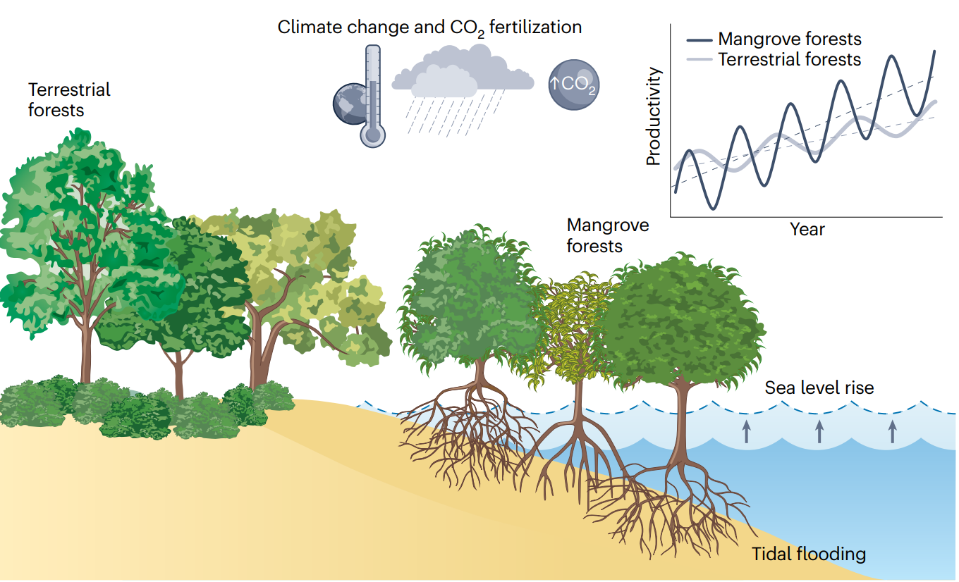
1. Mangrove forests are more sensitive to climate change than terrestral forests
Mangroves are often treated as ecologically similar to terrestrial forests in large-scale carbon cycle studies, yet their tidal environment and distinctive ecophysiology suggest that they may respond to climate change in fundamentally different ways. To test this explicitly, we compared mangroves only with geographically adjacent terrestrial evergreen broadleaf forests, using nearby inland forests as controls so that both groups shared the same regional climate and environmental background. By restricting the analysis to undisturbed, high-coverage forests, this paired design allowed us to isolate the unique signal of the tidal environment. We found that mangroves exhibited both stronger long-term increases in productivity and greater interannual variability than adjacent terrestrial forests. These differences were mainly driven by a stronger CO2 fertilization effect in mangroves, together with their higher sensitivity to precipitation and sea-level fluctuations. The findings highlight the need to explicitly represent coastal ecosystems in Earth system and vegetation models, and they suggest that mangroves may gain carbon faster under rising CO2 while also being more vulnerable to hydroclimatic stress.
Publication: Zhang, Z., Luo, X., Friess, D. A., Wang, S., Li, Y., & Li, Y. (2024). Stronger increases but greater variability in global mangrove productivity compared to that of adjacent terrestrial forests . Nature Ecology & Evolution , 8, 239–250.
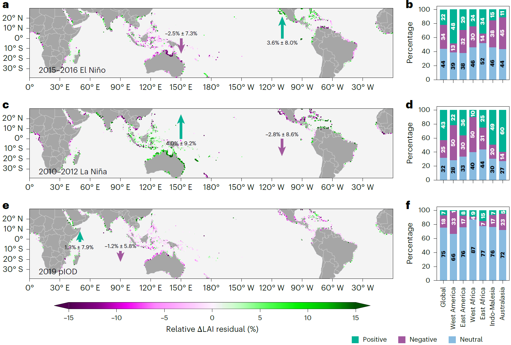
2. Sea-level fluctuations as a key driver of global mangrove growth
This study examines how large-scale climatic oscillations shape mangrove growth worldwide. Using global satellite observations from 2001 to 2020, we show that ENSO and IOD drive widespread but spatially contrasting mangrove responses, producing a seesaw-like pattern in which mangroves decline in the western Pacific and increase in the eastern Pacific during El Niño, with the reverse during La Niña. By attributing these anomalies to multiple environmental drivers, we found that short-term sea-level fluctuations are the dominant mechanism behind this global pattern, while drought exerts additional control in parts of the Indian Ocean. These findings demonstrate that mangrove growth is tightly coupled to oceanographic variability and underscore the importance of incorporating sea-level oscillations into projections of blue carbon stability and coastal ecosystem resilience.
Publication: Zhang, Z., Luo, X., Friess, D. A., & Li, Y. (2025). Global mangrove growth variability driven by climatic oscillation-induced sea-level fluctuations . Nature Geoscience , 8, 239–250.
II. Coastal remote sensing
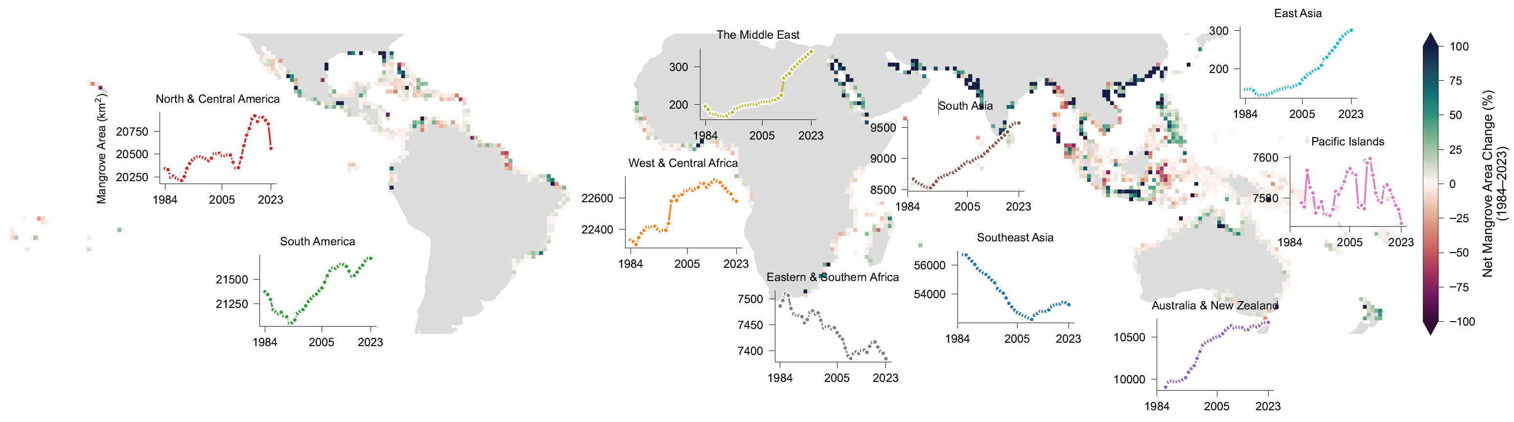
1. Global mangrove dynamics over the past four decades
Mangroves are often reported as a disappearing coastal ecosystem because of deforestation and shoreline erosion, yet their long-term trajectory in both area and canopy condition has remained surprisingly uncertain. This study addresses that gap by developing a global mangrove canopy cover dataset to examine how loss, degradation, regrowth, and natural expansion have jointly shaped mangrove change over recent decades. The analysis shows that while mangrove conversion and canopy degradation have occurred, these declines have increasingly been offset by regeneration and especially natural seaward expansion, resulting in an unexpected net canopy gain at the global scale in the last decade. This finding challenges the common narrative of uniform mangrove decline and reveals a more dynamic picture in which resilience, recovery, and expansion are also major components of global mangrove change. The study provides a new perspective on how mangrove ecosystems are responding to environmental change and offers an important basis for improving conservation, restoration, and blue carbon assessments worldwide.
Publication: Zhang, Z., Murray, N., Song, X. P., Bunting, P., Worthington, T., Fatoyinbo, L., ... & Friess, D. A. (2025). Unexpected canopy gain in Earth’s mangrove forests linked to natural expansion and regrowth . Science, 392(6802), 1082-1087.
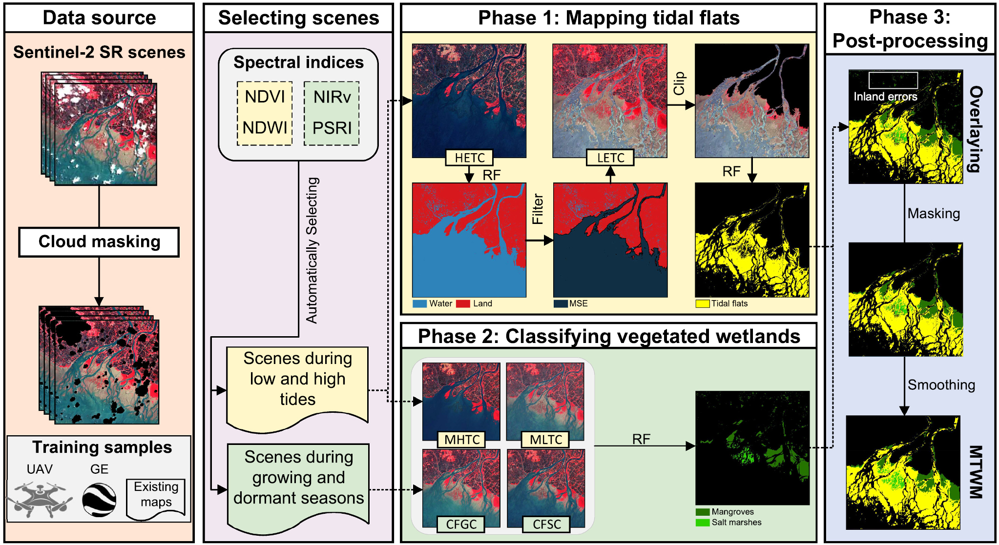
2. Integrating tidal level and phenology information for mapping tidal wetlands
Accurate mapping of tidal wetlands is essential for understanding coastal biodiversity, blue carbon, and ecosystem change, but it remains challenging because tidal inundation, frequent cloud cover, and spectral similarity with inland land cover often obscure wetland boundaries in satellite images. To address this problem, this study developed a new remote sensing algorithm, MTWM-TP, that integrates tide-level and phenological information to simultaneously map mangroves, salt marshes, and tidal flats from Sentinel-2 imagery. By generating noise-free composite images representing different tidal stages and vegetation phenological periods, the method greatly improves the separation of intertidal wetlands from inland landscapes and the distinction between evergreen mangroves and deciduous salt marshes. Applied across East Asia, the framework produced a 10 m resolution map with an overall accuracy of 97.02%, providing the first sub-continental, spatially explicit estimate of tidal wetland composition in the region. This work offers a practical and scalable remote sensing solution for coastal ecosystem monitoring and provides an important foundation for biodiversity conservation, wetland management, and blue carbon restoration.
Publication: Zhang, Z., Xu, N., Li, Y., & Li, Y. (2022). Sub-continental-scale mapping of tidal wetland composition for East Asia: A novel algorithm integrating satellite tide-level and phenological features . Remote Sensing of Environment. 269, 112799.
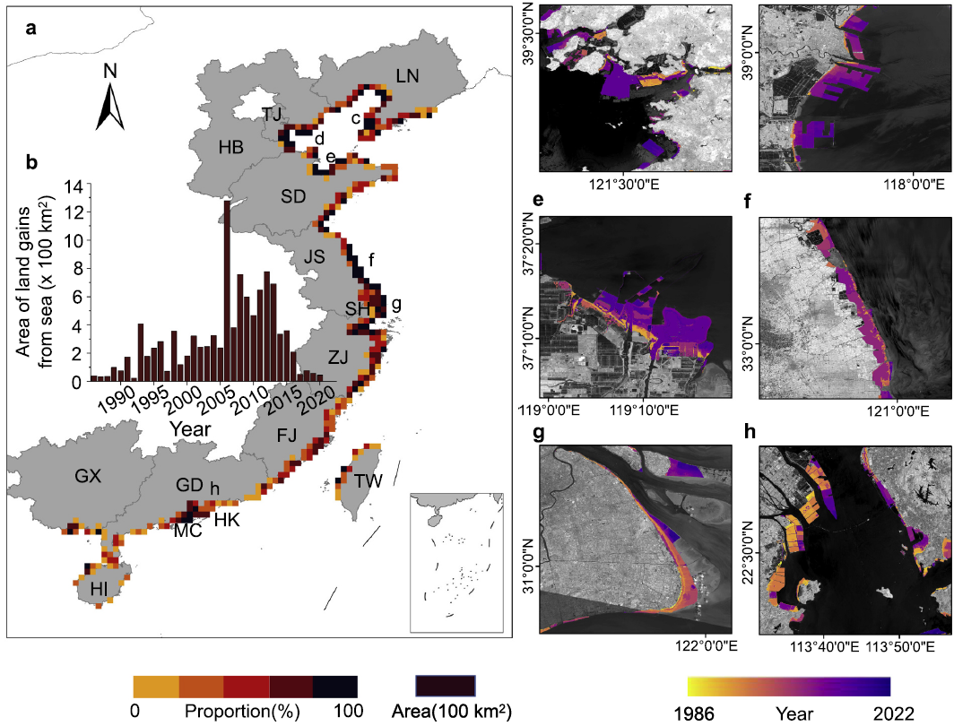
3. A fully automatic framework to detect urban expansion
This study presents FADUS, a fully automatic method for detecting long-term urban sprawl from satellite imagery without manual training samples. By combining automatic sample generation, supervised classification, and a tidal module for coastal environments, the framework can track both inland and seaward urban expansion across large regions and long time periods. Applied to China’s coast, it revealed a dramatic but often overlooked process of seaward urban sprawl, showing how urban growth has increasingly extended into former sea areas and transformed coastal ecosystems.
Publication: Zhang, Q., Zhang, Z., Xu, N., & Li, Y. (2023). Fully automatic training sample collection for detecting multi-decadal inland/seaward urban sprawl . Remote Sensing of Environment. 298, 113801.
III. Coastal ecology
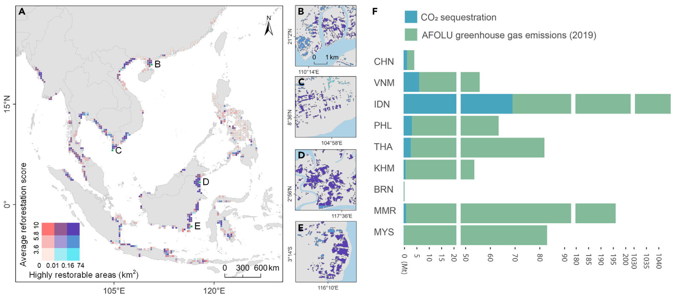
1. Mangrove restoration has large carbon benefits
Mangrove restoration is widely recognized as a powerful nature-based solution for climate mitigation, but restoration outcomes depend strongly on where it is implemented. This study focuses on one of the most important but underused opportunities for mangrove recovery: aquaculture ponds that were historically converted from mangrove forests. Using long-term satellite observations, aquaculture pond maps, and habitat suitability modeling, we quantified where mangroves lost to aquaculture can be feasibly restored across China and Southeast Asia and estimated the associated blue carbon benefits. We found that aquaculture expansion has caused the loss of 165,079 ha of mangroves since 1996, and that about 60% of these lost areas still retain suitable biophysical conditions for restoration. Priority restoration in these historically occupied areas could remove 84 (75–96, 95% CI) Mt CO2, with Indonesia emerging as the most important restoration hotspot. By linking restoration feasibility with carbon gains and economic considerations, this work provides spatially explicit guidance for cost-effective mangrove restoration and shows how restoring mangroves in former aquaculture landscapes can make meaningful contributions to national climate goals and blue carbon strategies.
Publication: Jiang, Y., Zhang, Z., Friess, D. A., Li, Y., Zhang, Z., Xin, R., ... & Li, Y. (2025). Restoring mangroves lost by aquaculture offers large blue carbon benefits . One Earth. 8(1), 101149.
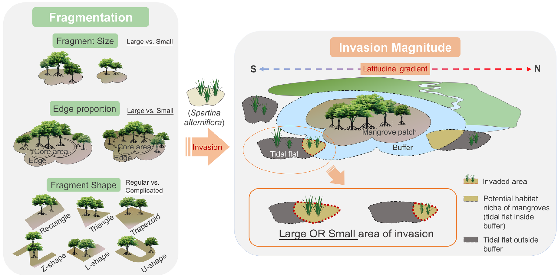
2. Biological invasion in coastal zone
Biological invasion and habitat fragmentation are two major threats to mangrove ecosystems, yet their interaction has rarely been examined at landscape scales. This study investigates how fragmentation influences the invasion of mangrove forests by the salt marsh plant Spartina alterniflora along the southeastern coast of China, using high-resolution remote sensing to quantify both mangrove landscape structure and invasion intensity. We found that smaller mangrove fragments, patches with higher edge proportions, and fragments with more regular shapes tend to experience more severe invasion, revealing a clear positive relationship between fragmentation and invasion magnitude. Importantly, this relationship is not spatially uniform: the fragmentation–invasion effect is much stronger in subtropical than tropical mangroves, indicating that climatic context strongly modifies mangrove vulnerability. These results provide the first spatially explicit evidence that fragmented mangrove landscapes are more susceptible to biological invasion and suggest that improving mangrove connectivity, reducing edge exposure, and optimizing restoration patch design can enhance resistance to invasion, especially in small subtropical mangrove forests.
Publication: Zhang, Z., Li, J., Li, Y., Liu, W., Chen, Y., Zhang, Y., & Li, Y. (2021). Spatially discontinuous relationships between salt marsh invasion and mangrove forest fragmentation . Forest Ecology and Management. 499, 119611.