
Continuous Global Mangrove Dynamics (1984-2023)
CGMD is a global annual mangrove dataset at 30 m resolution derived from Landsat imagery, providing time series of mangrove extent and fractional canopy cover from 1984 to 2023. The dataset captures long-term mangrove loss, gain, degradation, and regrowth, and offers a new basis for studying global mangrove dynamics under climate change and human disturbance.
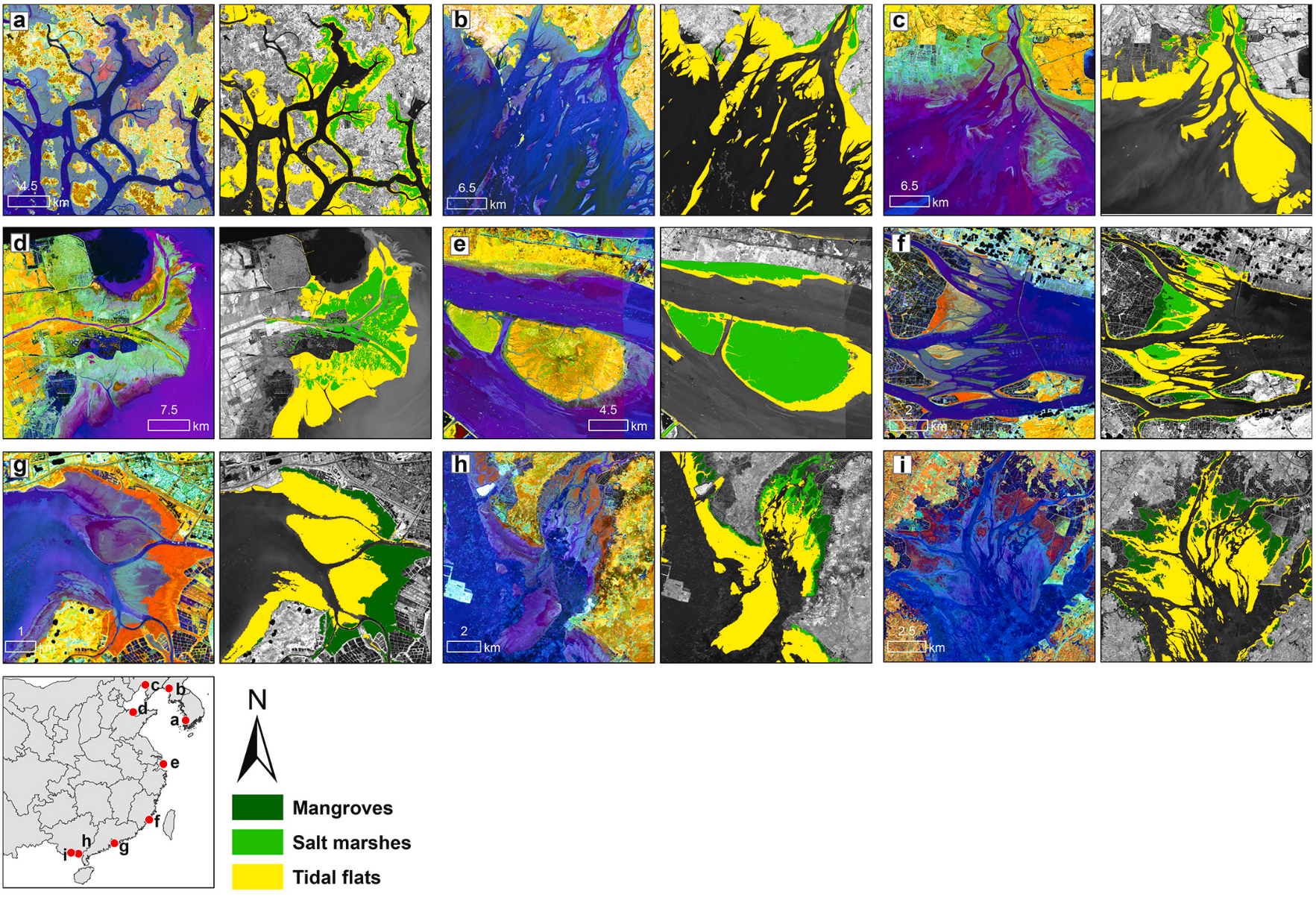
Tidal wetlands in East Asia (2020)
This dataset provides a high-resolution (10 m) map of tidal wetlands across East Asia in 2020, covering coastal regions of China, North Korea, and South Korea. It identifies three major tidal wetland types, including mangroves, salt marshes, and tidal flats. The dataset has been widely adopted in high-quality studies, such as Qi et al. , demonstrating its value for coastal ecosystem monitoring, blue carbon assessment, and coastal change analysis. In addition, it was independently evaluated as the most accurate tidal wetland dataset for East Asia, highlighting its reliability for both scientific research and policy applications.
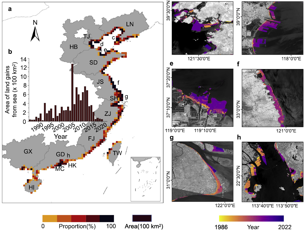
Seaward urban expansion in China (1986-2022)
This dataset provides annual maps of coastal reclamation across China from 1986 to 2022 at 30 m resolution. Unlike most existing urban expansion datasets, which mainly track inland urban growth, this dataset integrates a tidal module to detect seaward expansion in coastal cities. It provides a unique long-term perspective on coastal urbanization and human-driven shoreline change, with important applications for studying wetland loss, coastal development, and environmental management.
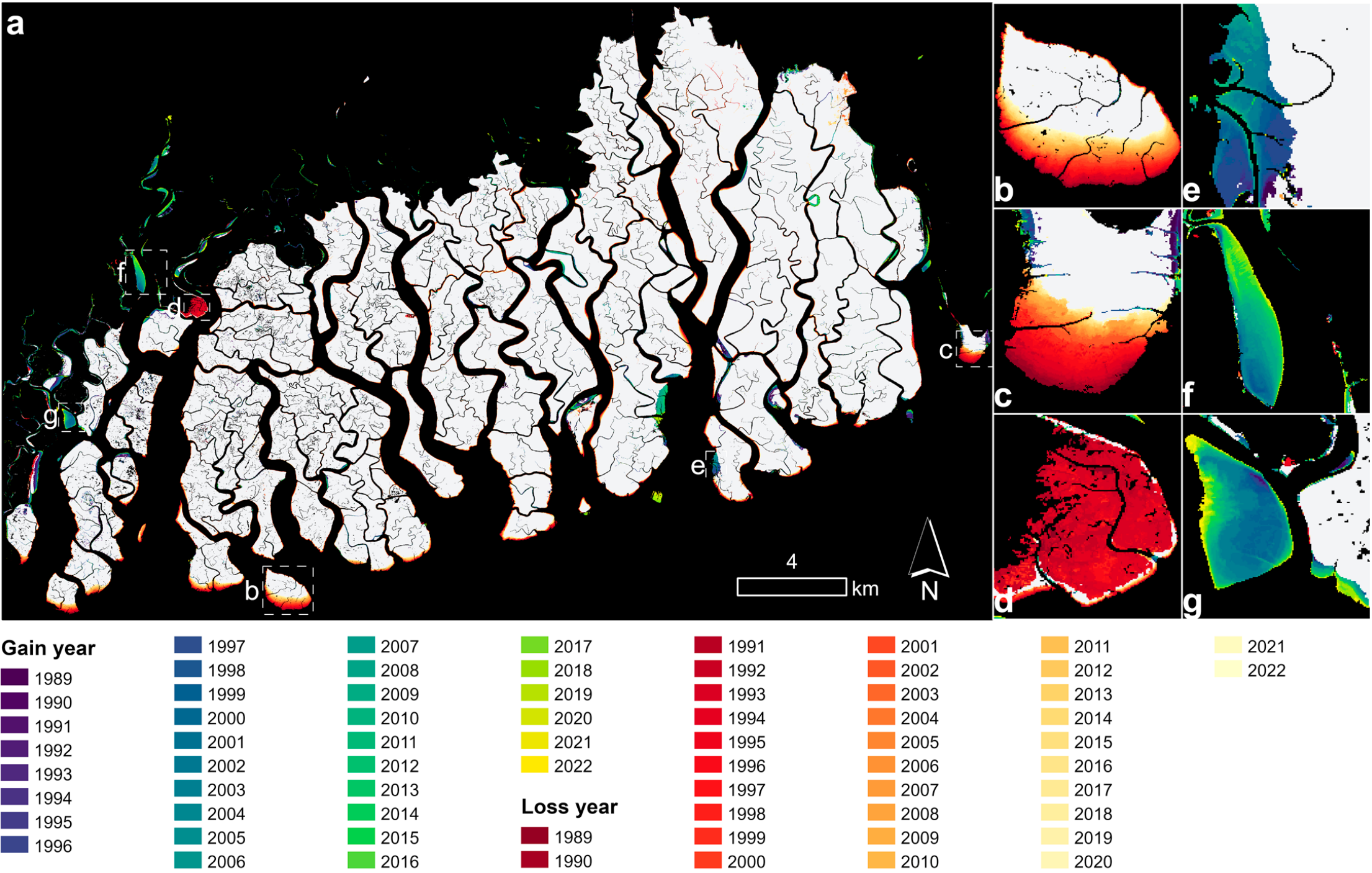
Sundarbans Annual Mangrove Change and Attribution (1988-2022)
This dataset provides annual 30 m maps of mangrove extent and change in the Sundarbans from 1988 to 2022 based on Landsat imagery. In addition to tracking yearly mangrove loss and gain, it uniquely includes pixel-level attribution of yearly change agents, identifying the likely drivers behind each changed pixel. This makes the dataset valuable not only for monitoring long-term mangrove dynamics, but also for understanding the processes and pressures shaping change in one of the world’s most important mangrove ecosystems.
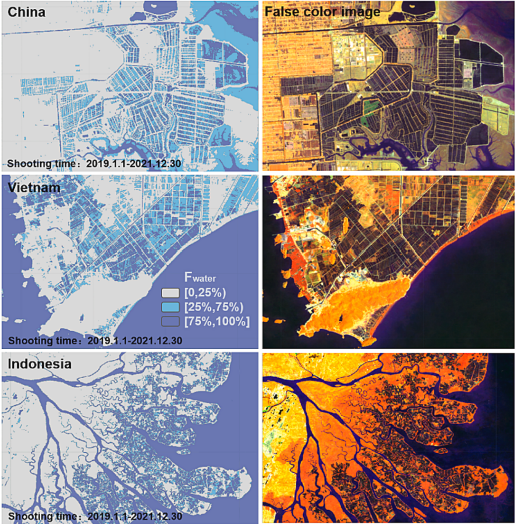
Coastal Aquaculture Ponds in China and Southeast Asia (1990–2020)
This dataset provides a 30-year record of coastal land-based aquaculture ponds across China and Southeast Asia derived from long-term Landsat imagery. Using an object-oriented classification framework and water-inundation frequency filtering, the dataset maps the spatial distribution and decadal dynamics of aquaculture expansion while reducing confusion with temporary water bodies and rice fields. The resulting dataset captures fine-scale features such as pond embankments and drainage channels, providing a detailed record of aquaculture-driven coastal change and wetland conversion.
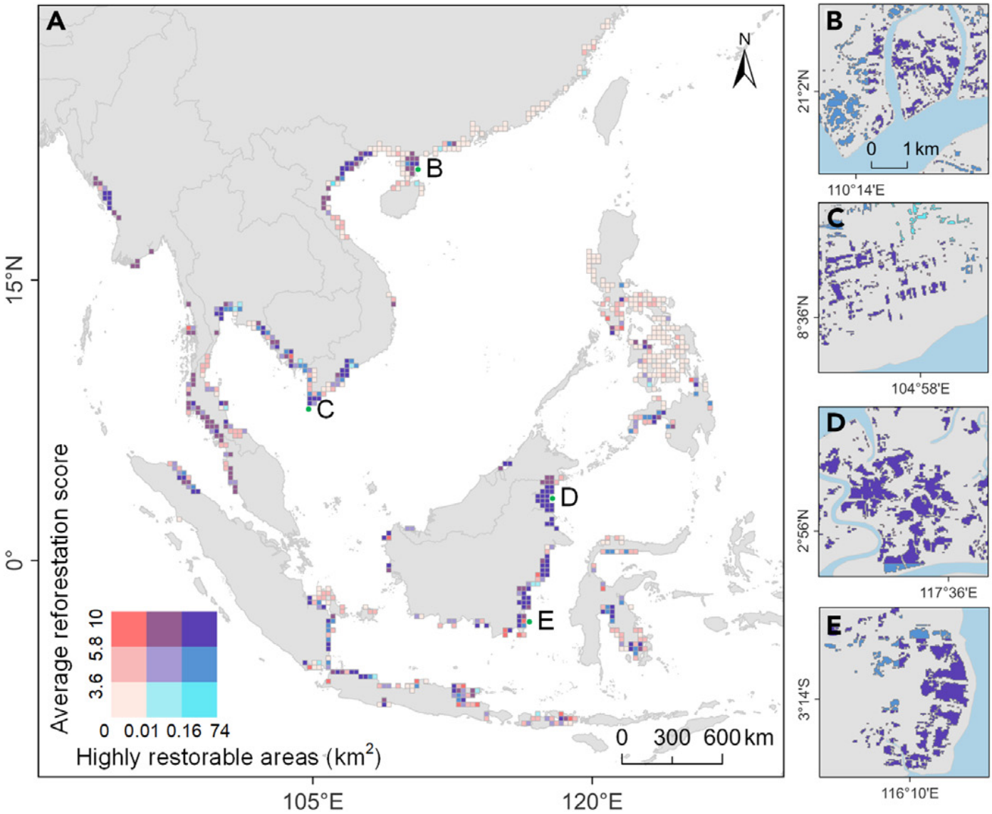
Biophysical Feasibility of Mangrove Restoration in China and Southeast Asia
This dataset provides patch-scale maps of mangrove restoration suitability for aquaculture ponds historically converted from mangroves in China and Southeast Asia. By combining long-term satellite observations with habitat suitability modeling, it identifies where restoration is most feasible and where blue carbon benefits are likely to be greatest. The dataset offers a practical tool for prioritizing mangrove restoration and supporting conservation and climate mitigation planning.